| In this Section: | |  | In the Spotlight | | News |  |
List of "In the Spotlight" Features
New Ocean Data from Suzanna Barth and CCAR
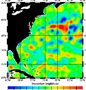
For Sea Surface Data, there is now, exciting NASA TOPEX and ERS-1 data to illustrate Sea Heights. This means students can look at how ocean heights and eddies relate to animal location and movement.
Also, this data can be compared with temperature, currents, velocities, phytoplankton, and even bathymetry data!
Suzanna Barth is a Research Assistant for the Colorado Center for Astrodynamics Research (CCAR) in Boulder, Colorado. She is completing her Doctorate Degree in Aerospace Engineering Science, specializing in Remote Sensing and Astrodynamics, where she develops uses for spacecraft instruments. These instruments are used to observe environments on Earth and other planets! Some instruments make use of RADAR (Radio Detection and Ranging) or LIDAR (Light Detection and Ranging); other instruments can detect heat emitted from a forest fire or even a cloud.

Suzanna Barth |
Suzanna works on measuring the temperature and salt concentrations beneath the ocean's surface and its effect on hurricanes using a combination of information from satellites, ships, and ocean buoys. In order to make these measurements, she works with meteorologists, oceanographers, and other aerospace engineers. This temperature information may be used to study the behavior of whales and other sea creatures!
Before she went back to school, Suzanna worked with scientists at NASA-Ames on a research aircraft that flew around the world using specialized instruments to look at volcanoes, the motion of the Earth's continents, and ozone research. These projects took her to Alaska, the coast of Antarctica, Thailand, and Chile as she provided engineering support to the scientists. Some of the instruments they used were further developed to fly on the Space Shuttle.
Suzanna started working as a technical writer and software engineer for jet aircraft, then discovered she loved working with instruments and scientists who wanted to study changes in the Earth, the behavior of animals, and changes in the Earth's atmosphere. She then decided to go back to school and become an engineer who worked with these scientists.
The satellite SEA HEIGHT imagery is taken by bouncing radar from a satellite to the ocean and back, and measuring the amount of time it takes to make the round trip. Information from the radar bounce is used to determine sea surface height, ocean waves and currents, and surface winds. In order to determine sea surface height changes in the range of a few centimeters, engineers and scientist must know the precise orbit of the satellite, variations in the shape of the Earth, how much water vapor (clouds) is in the path of the bouncing radar signal, the drag on the satellite as it comes in contact with the Earth's atmosphere, and even the state of the sun and solar flares which also changes the exact orbit of the satellite. After all these (and many more) corrections are made, engineers give scientists pictures like the one below.
|