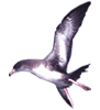
Image Credit: USGS/Greg Lasley


Animals:

red.gif102531**

** We have not received data for this animal in 7 days or more. This does not necessarily mean the tag is inactive.


Map Date:


Pink-footed Shearwater (Final Map for 2012)

Note: Blinking dots represent approximately where the animal was at the time of the map.

Sea Surface Temperature Weather Sea Ice Sea Height Currents Wind
Sea Surface Temperature color key


Location Data provided by:

Pink-footed Shearwater Conservation is a collaborative project of the Juan Fernández Islands Conservancy program of Oikonos Ecosystem Knowledge in partnership with U.S. Geological Survey and American Bird Conservancy.


Earth Data provided by:
  • SST [11 µ day] (Aqua-MODIS), NASA/Goddard Space Flight Center