|
|
List of "In the Spotlight" Features New Maps this Season!
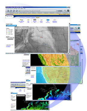
The 2006 season offers a new and improved interactive mapping system! In the Signals of Spring program, students become Life and Earth Science experts. Depending on their expertise (Land Species, Geography, Vegetation, Weather, Marine Species, Bathymetry, Phytoplankton, or Sea Surface Temperature), Student Expert Teams analyze animal location data overlayed on top of Earth imagery from their field. |
| Sponsored by: | |
| National Aeronautics and Space Administration (NASA Award NCC5433) | |
| National Oceanic & Atmospheric Administration (NOAA Award NA06SEC4690006) |
Copyright © 2024 U.S. Satellite Laboratory, Inc. All rights reserved.